Tuesday, 28 April 2026
Meteo Giornale English
  • Home
    • Italiano
    • Español
    • Français
    • Deutsch
  • Weather Forecast
    • Weather Forecast 7 days
    • Weather Forecast 15 days
  • Climate change
  • Weather Forecast Editorial
    • Weather Focus
    • Weather News
    • Wiky Weather
  • Magazine
  • Multimedia
  • Travel and Climate
Meteo Giornale
Página de inicio Weather News

Weather: Cyclone Stalled in Italy, Risk of FLOODS in These Regions

James Miller por James Miller
Sep 17 2024 - 11:30
en Weather News
Tiempo de lectura: 2 mins de lectura
A A
Share on FacebookShare on Twitter


As the minutes pass, the weather worsens more and more from north to south, indicating the development of a new depression within the Mediterranean, as widely predicted in the weather forecasts of recent days.

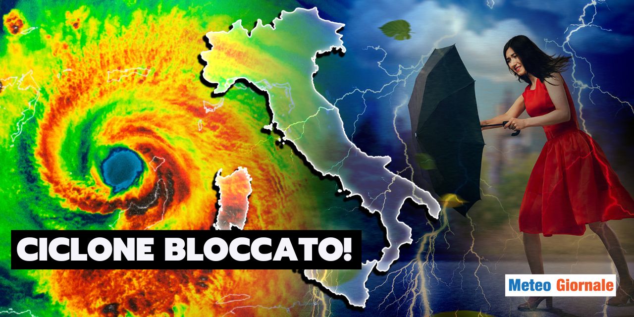
This is the “backtrack” of the cyclone that has severely hit the Balkans, Eastern Europe, and Austria in the past 72 hours, the same one responsible for the temperature drop that arrived in Italy last week.  

READ ALSO

Weather: the cold advances in Europe, what to expect

Epiphany Weather: Sudden Anomalous Heat with Over 20°C in These Regions


The cyclone backtracks

This cyclone is backtracking, plunging once again into the “mare nostrum,” ready to generate a new rather significant wave of bad weather, which certainly will not go unnoticed.

The cool air coming from the Balkans heading towards the Mediterranean is carving out a deep depression in the Tyrrhenian Sea, which is already triggering showers and local strong thunderstorms in the central-south.   In the coming hours, the weather will worsen significantly, especially in the central regions, exactly where we expect the most intense and persistent phenomena.

The central Adriatic regions will be the most affected by downpours in the next 72 hours, especially on Wednesday 18 and Thursday 19.

Considering that the cyclone will remain literally stuck in the Mediterranean, due to the presence of high pressures all around (both in North Africa and Northern Europe), it is clear that we are facing fairly stationary phenomena.  


The most affected regions

When we are faced with stationary phenomena, the rainfall accumulations can rise dramatically, especially near the mountains, due to the stau effect.

Indeed, all calculation centers show potentially damaging forecasts for Romagna, Marche, and Abruzzo, which could receive total rainfall accumulations, by Thursday, exceeding 200-250 mm. These are excessive accumulations in such a short time, which would fall mainly in the Apennines.   We expect strong thunderstorms and downpours also in Puglia, Lazio, Campania, Calabria, Basilicata, while elsewhere we will have weaker and sporadic phenomena.

For an improvement in weather conditions, we will have to wait for the weekend, when high pressure could reappear in Italy.


Our articles from Meteo Giornale are on Google News, follow us for free!
Google News Follow our feed
CompartirTweetFijar
Publicación anterior

Weather: the heat returns earlier than expected, the turning point date is set

Siguiente publicación

WEATHER September: the last five years of extreme variations in Italy

James Miller

James Miller

Relacionado Publicaciones

Weather: the cold advances in Europe, what to expect thumbnail
Weather News

Weather: the cold advances in Europe, what to expect

January 2, 2025
Epiphany Weather: Sudden Anomalous Heat with Over 20°C in These Regions thumbnail
Weather News

Epiphany Weather: Sudden Anomalous Heat with Over 20°C in These Regions

January 2, 2025
Weather: January 3rd, first storm of the year, rain and snow, affected areas thumbnail
Weather News

Weather: January 3rd, first storm of the year, rain and snow, affected areas

January 2, 2025
Siguiente publicación
WEATHER September: the last five years of extreme variations in Italy thumbnail

WEATHER September: the last five years of extreme variations in Italy

Tourism in Monte Nerone: skiing, snowshoeing, and hiking in the Marche region thumbnail
Travel and Climate

Tourism in Monte Nerone: skiing, snowshoeing, and hiking in the Marche region

January 2, 2025
Weather: the cold advances in Europe, what to expect thumbnail
Weather News

Weather: the cold advances in Europe, what to expect

January 2, 2025
Trip to Málaga: from the Phoenicians to Picasso, art and history and an ideal climate thumbnail
Travel and Climate

Trip to Málaga: from the Phoenicians to Picasso, art and history and an ideal climate

January 2, 2025
Trip to Rome: How to Dress for Cool and Humid Weather. Practical Tips thumbnail
Travel and Climate

Trip to Rome: How to Dress for Cool and Humid Weather. Practical Tips

January 2, 2025

Innovazione Scienza S.r.l. unipersonale P.IVA/C.F. 10463560960- Milano (MI)

Sin resultados
Ver todos los resultados
  • Home
    • Italiano
    • Español
    • Français
    • Deutsch
  • Weather Forecast
    • Weather Forecast 7 days
    • Weather Forecast 15 days
  • Climate change
  • Weather Forecast Editorial
    • Weather Focus
    • Weather News
    • Wiky Weather
  • Magazine
  • Multimedia
  • Travel and Climate

Innovazione Scienza S.r.l. unipersonale P.IVA/C.F. 10463560960- Milano (MI)