
A severe wave of bad weather will hit Italy over the weekend with decidedly winter-like weather and falling temperatures, which will also lead to the arrival of snow down to low altitudes, aided by intense precipitation.
A cyclonic vortex, fueled by cold polar air, will deepen over Italy. In addition to rain, thunderstorms, and gale-force winds, snow will also return.
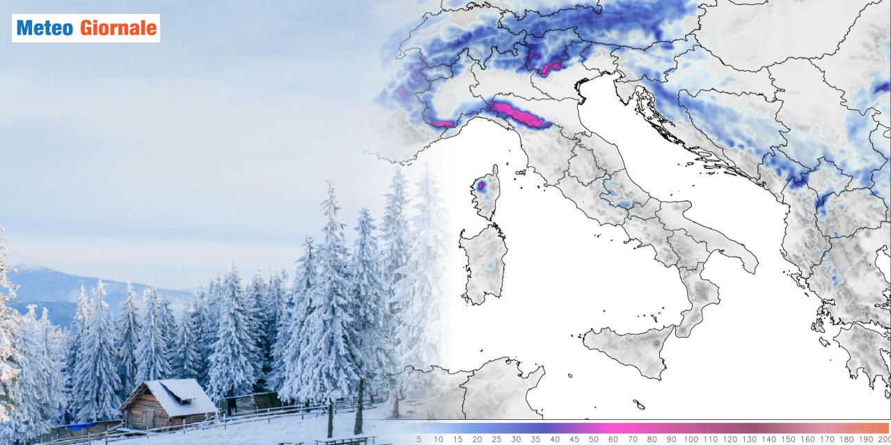
The closer proximity to the event allows us to go into more detail, especially on the distribution of the expected snow across various regions. We particularly focus on Northern Italy where it could occasionally snow at low altitudes. The position of the low that will deepen over the Italian seas is not yet fully defined and this will affect the evolution, which may undergo variations in local detail.
The distribution of precipitation as well as the estimation of accumulations and snow levels are closely linked to the Alpine orography that acts as a barrier. The severe deterioration will begin to manifest from the afternoon-evening of Saturday, December 7th, with the snow level starting to drop towards the end of the day at least in the Alps.
The snow limit will drop to around 1300-2000 feet in some pre-Alpine areas of Piedmont and where the precipitation will be more intense. In the presence of stronger precipitation, a few flakes at even lower altitudes are not excluded.
Among the areas where mixed precipitation or local snowflakes could touch the plains, we highlight the Piacenza area, but also some sectors between Lower Piedmont and Lower Lombardy.
Sunday 8th with heavy snow in some parts of the Alps and the Apennine ridge
The mix of very cold air at high altitudes and precipitation of a certain intensity could at times favor the lowering of the snow level to touch the plains. Snow will then fall heavily on the Alps and Northern Apennines, with accumulations by 24:00 on Saturday of up to 8-12 inches and higher in the Aosta Valley sectors. On Sunday 8th, the snow will be localized in the Eastern Alps in the first part of the day, then the bulk of the snowfalls will concentrate along the Apennines.
The snow level will fluctuate between 1600-2300 feet in the Alps and above 2300-3000 feet in the Apennines, at lower altitudes on the Ligurian and Tuscan-Emilian ridges. In general, during Sunday, up to 16-24 inches of fresh snow may fall in the Eastern Alps and Northern Apennines, including the Ligurian sectors.
Snow accumulations of up to 8-12 inches are expected locally in the central sectors of the Apennine ridge and on the Gennargentu in Sardinia. Snowfalls will be less abundant in the rest of the Apennines, awaiting further contributions at the beginning of next week.
It should be noted that in the areas of Southern Italy and Sicily, it will snow only in the mountains, generally at altitudes above 4000 feet.
It will be a nice winter event, but nothing so exceptional.


