Sunday, 10 May 2026
Meteo Giornale English
  • Home
    • Italiano
    • Español
    • Français
    • Deutsch
  • Weather Forecast
    • Weather Forecast 7 days
    • Weather Forecast 15 days
  • Climate change
  • Weather Forecast Editorial
    • Weather Focus
    • Weather News
    • Wiky Weather
  • Magazine
  • Multimedia
  • Travel and Climate
Meteo Giornale
Página de inicio Multimedia

Incredible gust front in northern Uruguay – what kind of clouds are these?

James Miller por James Miller
Oct 14 2023 - 13:43
en Multimedia
Tiempo de lectura: 2 mins de lectura
A A
Share on FacebookShare on Twitter


Analysis of the Meteorological Phenomenon: Stratocumulus Volutus

Description of the Phenomenon

Characteristics of Stratocumulus Volutus Clouds

Recently, a meteorological phenomenon has attracted attention in northern Uruguay, in Cerro Largo.

It is an impressive cloud formation, captured in a video and shared by the National Meteorological Service.

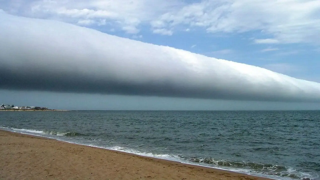
These clouds, known as Stratocumulus Volutus, are low tubular-shaped clouds.

They are typically visible at the end of the dry season, from September to mid-November, in the Gulf of Carpentaria, in northeastern Australia, where they are known as Morning Glory.

However, they can also be observed in other parts of the world.

Stratocumulus Volutus are roll-shaped clouds with a typical width of 1 or 2 km and lengths exceeding 100 km, sometimes occupying the entire sky from horizon to horizon.

These clouds can travel alone or in groups and move quickly, at average speeds of 30-45 km/h.  

READ ALSO

The Shortest Day of the Year: Discovering the Winter Solstice

Rare tornado hits downtown San Francisco. Weather video


Presence of Altocumulus Lenticularis

In the video, on top of the Stratocumulus Volutus, another type of cloud is visible.

These are laminar-shaped clouds, with soft, wavy edges and a bright white color.

These clouds are called Altocumulus Lenticularis and are of medium type, often visible in mountainous areas.

The presence of these clouds indicates strong turbulence and wind shear at mid-levels of the troposphere.  


Atmospheric Waves and Surface Effects

Generation of Atmospheric Waves

The Volutus and Lenticularis represent the visible part of an atmospheric wave.

Just as there are waves in the sea, there are also atmospheric waves because air is a fluid like water, subject to turbulence.

These waves can be generated by the interaction of the airflow with an orographic obstacle, for example.

Sometimes, Stratocumulus Volutus are associated with cold air coming out of storms and moving like a surface cold front (gust front).

The gust front is therefore a separation zone between two air masses of different temperature and density.

In this case, it is difficult to determine whether these clouds were associated with nearby storms.

For this, radar images or an animation of the visible channel of the Meteosat satellite are essential.


Effects of Stratocumulus Volutus on the Surface

The passage of waves associated with Stratocumulus Volutus produces pressure oscillations on the surface, easily detectable on a barograph.

After the waves, the pressure increases and remains stable for several hours.

In some cases, the pressure increase is more than one millibar in a few minutes.

With the passage of these clouds, the wind tends to strengthen, becomes gusty, and changes direction.

The duration usually does not exceed five minutes and is associated with each individual roll.

Although the wind associated with the Morning Glory is rarely intense, these clouds are monitored at airports due to the abrupt changes in direction that can affect the organization of takeoffs and landings.

Stratocumulus and Altocumulus rarely produce precipitation, and it is always weak in nature.

In Stratocumulus Volutus, the vertical development of the cloud usually does not exceed 1000 meters, so precipitation is rare in these cases.

This type of laminar cloud requires atmospheric stability with horizontal wind flows.


Our articles from Meteo Giornale are on Google News, follow us for free!
Google News Follow our feed
CompartirTweetFijar
Publicación anterior

Incredible gust front in northern Uruguay – what kind of clouds are these?

Siguiente publicación

The first snow on the plains, here it is. Picture-perfect weather video

James Miller

James Miller

Relacionado Publicaciones

The Shortest Day of the Year: Discovering the Winter Solstice thumbnail
Multimedia

The Shortest Day of the Year: Discovering the Winter Solstice

December 17, 2024
Rare tornado hits downtown San Francisco. Weather video thumbnail
Multimedia

Rare tornado hits downtown San Francisco. Weather video

December 15, 2024
The Pinglu Rift Valley: a geological wonder on the Loess Plateau, Shanxi thumbnail
Multimedia

The Pinglu Rift Valley: a geological wonder on the Loess Plateau, Shanxi

December 6, 2024
Siguiente publicación
The first snow on the plains, here it is. Picture-perfect weather video thumbnail

The first snow on the plains, here it is. Picture-perfect weather video

Tourism in Monte Nerone: skiing, snowshoeing, and hiking in the Marche region thumbnail
Travel and Climate

Tourism in Monte Nerone: skiing, snowshoeing, and hiking in the Marche region

January 2, 2025
Weather: the cold advances in Europe, what to expect thumbnail
Weather News

Weather: the cold advances in Europe, what to expect

January 2, 2025
Trip to Málaga: from the Phoenicians to Picasso, art and history and an ideal climate thumbnail
Travel and Climate

Trip to Málaga: from the Phoenicians to Picasso, art and history and an ideal climate

January 2, 2025
Trip to Rome: How to Dress for Cool and Humid Weather. Practical Tips thumbnail
Travel and Climate

Trip to Rome: How to Dress for Cool and Humid Weather. Practical Tips

January 2, 2025

Innovazione Scienza S.r.l. unipersonale P.IVA/C.F. 10463560960- Milano (MI)

Sin resultados
Ver todos los resultados
  • Home
    • Italiano
    • Español
    • Français
    • Deutsch
  • Weather Forecast
    • Weather Forecast 7 days
    • Weather Forecast 15 days
  • Climate change
  • Weather Forecast Editorial
    • Weather Focus
    • Weather News
    • Wiky Weather
  • Magazine
  • Multimedia
  • Travel and Climate

Innovazione Scienza S.r.l. unipersonale P.IVA/C.F. 10463560960- Milano (MI)