

We are only at the beginning of Winter, but this year the weather promises different scenarios from those of recent years.
Snow has already arrived in some parts of Italy, in some cases with flurries even touching the plains, at least in the North.
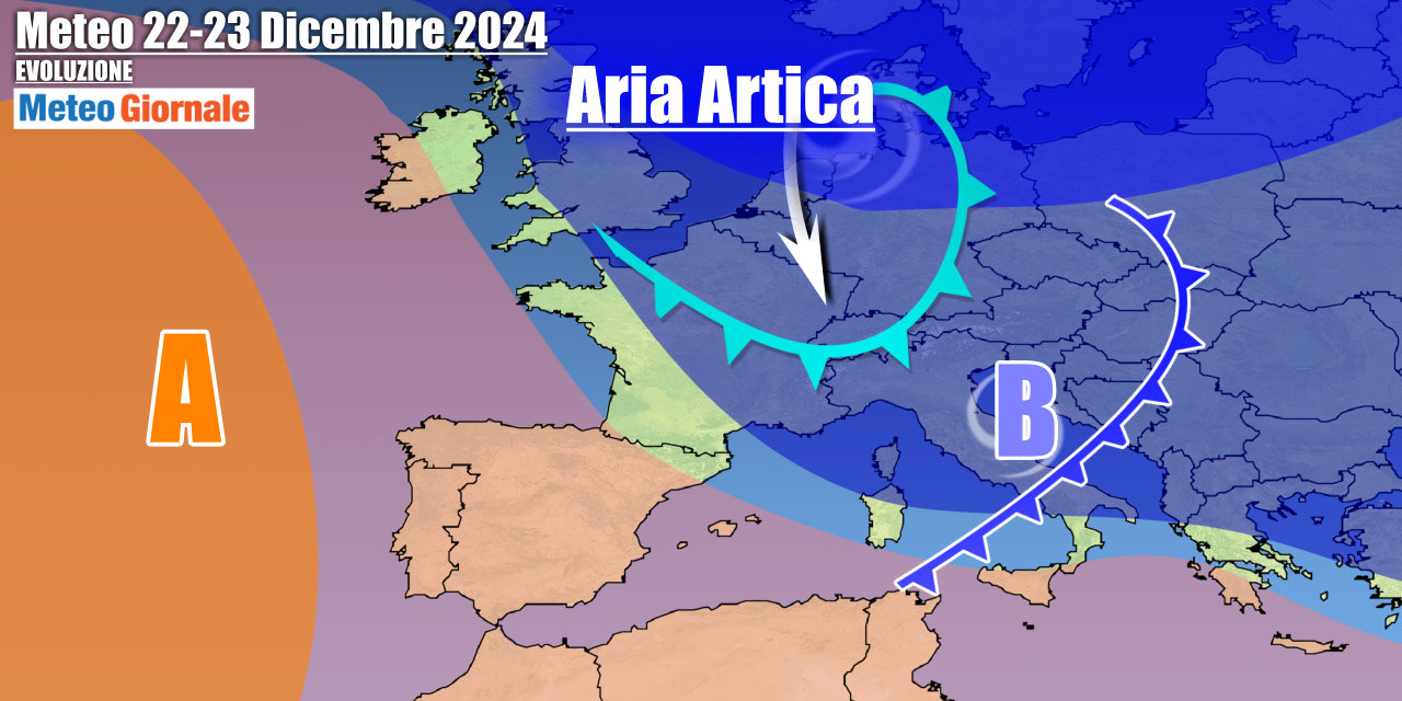
Now comes the best part, with cold and snow as protagonists right during the Christmas period. On second thought, imagining snow during the Christmas period may seem totally absurd. The trend of recent years is absolutely eloquent.
High pressures had monopolized the scene, preventing cold and snow waves not only in Italy but also in much of Europe. This Winter we are facing a newfound semblance of normality. One wonders if it could be the right year for the return of snow down to the plains. It would be about time, especially in the Po Valley where snow was a regular occurrence every year.
Now, however, a nice widespread snowfall has not happened for several years. The potential conditions appear favorable, at least on paper.
Climate indices are in our favor and especially we observe a much more vulnerable and not so compact Polar Vortex.
Remember that when the Polar Vortex is compact and spinning at full speed, it holds the colder air to itself. On the contrary, when the Polar Vortex is weaker, it creates a more favorable situation for the descent of cold air to our latitudes.
The Polar Vortex is oscillating between moments of recovery and moments of greater weakness. It could be the right season, especially in case of a stratwarming trigger. Remember that stratwarming is a sudden warming at the stratosphere level that could literally shatter the Polar Vortex, causing a so-called split.
Some major cold and snow waves from the past have resulted from this so-called “major” event. In the last fifty years, there is certainly one winter that stands out for its severity: that of 1985.
That year left an indelible mark on collective memory, particularly for the month of January, labeled as the coldest in at least half a century in Italy. In that January almost 40 years ago, the mercury column touched record numbers, with temperatures dropping to -18°F in the Bologna plain and -13°F in the Arno Valley, in Tuscany. These are glacial temperatures, with these peaks emphasized by the presence of snow on the ground and the so-called albedo effect. That period saw an Italy besieged by extreme cold, ice, and heavy snowfalls, which immobilized the country for days.
To fully understand the extent of such an event, it is necessary to start from December 1984.
At that time, Europe was under the hegemony of a high-pressure regime. In this context, much of the European continent recorded rather high atmospheric pressure values. The first half of December 1984 was characterized by a high-pressure regime over Italy and much of Europe, but it was not Siberian cold.
The Russian anticyclone was still relegated to the east. Nothing foreshadowed what would happen next. The real cold manifested itself later.
It is intriguing to observe how until that moment, the Icelandic depression had remained relatively weak, while rainfall in the Mediterranean area remained average. The reflection we can draw is how sometimes, the most extreme climatic events develop unexpectedly, radically altering atmospheric conditions in a surprising way. No one can rule out the repetition of a similar cold event, even if the return times are increasingly extended.


